
Business Details
18 Years
experience
Your Trusted Land Surveying Experts in Medicine Hat
Established in 2008, Benchmark Geomatics combines scientific precision with legal expertise to deliver accurate land surveying solutions. Our team leverages state-of-the-art equipment and techniques while maintaining an old-fashioned commitment to personalized service. With over 30 years of combined experience in Alberta, we specialize in legal land surveying, construction surveys, and UAV drone technology. Our work ensures compliance with municipal regulations and provides critical data for property transactions, infrastructure projects, and development planning. As a 100% locally owned and operated Medicine Hat business, we prioritize community needs while maintaining national industry standards.Our professionals hold memberships in the Alberta Land Surveyors' Association and adhere to strict ethical guidelines. We offer comprehensive services including Real Property Reports, topographic surveys, and municipal compliance documentation. Our focus on accuracy, affordability, and timely delivery has earned us recognition from the Better Business Bureau and local construction associations. Through continuous investment in technology and staff development, we maintain our position as a trusted partner for both private and public sector clients across southern Alberta.

Services
Legal Land Surveying
Construction Surveys
UAV Drone Surveys
Topographic Surveys
Municipal Compliance Services
Details
- Year established: 2008
Highlights and features
- We offer 30+ years of combined Alberta surveying experience
- Our team uses state-of-the-art surveying technology
- 100% locally owned and operated in Medicine Hat
- We provide both legal and construction survey expertise
- Our services include municipal compliance documentation
Services
Legal Land Surveying
Our legal land surveying services determine precise property boundaries using specialized equipment and legal knowledge. We create official documentation for property transactions, resolve boundary disputes, and ensure compliance with Alberta land use regulations. Our Alberta Land Surveyors provide legally recognized reports used by property owners, municipalities, and financial institutions.
UAV Drone Surveys
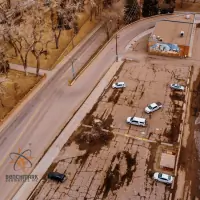
UAV drone surveys capture high-resolution aerial data from 120 meters above ground. We create detailed ortho-images and 3D digital models for construction monitoring, land development, and infrastructure projects. This technology provides cost-effective, rapid data collection for large-scale commercial and industrial sites across southern Alberta.
Construction Surveys
Our construction surveying services support accurate project execution through precise layout and monitoring. We handle flood restoration, subdivision development, dam construction, and commercial projects. Our team provides road/bridge surveys and railway project documentation to ensure compliance with engineering specifications and municipal requirements.
Real Property Reports
Real Property Reports show property boundaries, improvements, easements, and encroachments. These legal documents help property transactions by identifying potential issues. We prepare RPRs for purchasers, sellers, realtors, and financial institutions, including municipal compliance certification to streamline development approvals in Medicine Hat.
Municipal Compliance
Municipal compliance services verify adherence to local land use bylaws. We prepare documentation for property developments, subdivisions, and infrastructure projects. Our team handles compliance applications with Medicine Hat authorities to ensure projects meet zoning regulations and avoid costly delays during construction or property transactions.
People
Adam Thompson
Project Manager - Legal Surveys
Alberta Land Surveyor with 20+ years experience specializing in parcel boundary determination. Holds a Geomatics Engineering degree from University of New Brunswick and active ALSA membership.
Kirby Finley
Senior Engineer - Civil Engineering and Design
Civil engineer with expertise in sustainable infrastructure solutions. Specializes in project management and innovative engineering practices for Medicine Hat developments while prioritizing safety and efficiency.
Graeme Teare
Project Manager - Construction Surveys
Geomatics Engineering Technologist with 10+ years managing large-scale projects. Experienced in flood restoration, dam construction, and industrial developments across southern Alberta's commercial and infrastructure sectors.
Questions
What is a Real Property Report?
A Real Property Report shows property boundaries, improvements, easements, and encroachments. It's used during property transactions to identify potential issues and ensure municipal compliance.
Do you provide municipal compliance certification?
Yes, we prepare and submit compliance documentation to Medicine Hat authorities to verify projects meet land use bylaws and zoning regulations.
What survey technologies do you use?
We combine traditional surveying equipment with UAV drone technology for aerial mapping and 3D modeling of large-scale projects.
Are you locally owned?
Yes, we're 100% locally owned and operated in Medicine Hat with 30+ years of combined Alberta surveying experience.
What construction survey services do you offer?
We provide site layout, progress monitoring, and as-built surveys for flood restoration, subdivisions, dam construction, and commercial developments.