
Business Details
44 Years
experience
Expert Surveying Services in Courtenay, BC
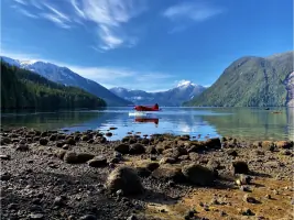
Established in 1982, our firm operates from Courtenay on Vancouver Island, serving clients across British Columbia's rugged terrain and remote coastal regions. We combine traditional legal survey expertise with cutting-edge technology, including GNSS positioning, laser scanning, drone LiDAR, and aerial photography. Our team's decades of experience enable us to tackle complex projects, from boundary retracements in wilderness areas to precision monitoring systems for industrial sites. We maintain our own De Havilland Beaver floatplane and Piper PA-18 Super Cub aircraft to access challenging locations, supported by advanced field equipment and office software.Our approach prioritizes client collaboration, leveraging technical innovation to deliver cost-effective solutions for property subdivisions, infrastructure development, and environmental assessments. We've completed landmark projects like BC Ferries' terminal mapping and hydroelectric facility surveys, earning recognition through the 2007 David Thompson National Award for Innovation in Geomatics. Our commitment to technological advancement ensures clients receive accurate, timely data through both aerial photogrammetry and terrestrial measurement methods.
Services
Boundary Surveys
Hydro Projects
Bathymetric Surveys
UAV LiDAR
Aerial Photography
Control Surveys
Engineering Surveys
First Nations Projects
Residential Development
Details
- Year established: 1982
Highlights and features
- Established in 1982 with decades of surveying expertise
- Owns a De Havilland Beaver floatplane for remote location access
- Utilizes cutting-edge LiDAR and GNSS technology
- Award-winning innovation in geomatics since 2007
- Team-based approach ensuring cost-effective solutions
Associations and certifications
- David Thompson National Award for Innovation in Geomatics
- Canadian Institute of Geomatics
Services
Boundary Surveys
We specialize in retracing historical land boundaries across challenging BC terrain. Our surveyors combine archival research with modern GNSS technology to resolve property disputes and establish accurate legal boundaries. With floatplane access to remote locations, we complete cadastral surveys for residential developments, First Nations projects, and industrial sites while maintaining precise documentation for government approvals.
Hydro Projects
Our team provides comprehensive surveying for hydroelectric developments from initial site assessment to construction. We've completed transmission line surveys for BC Hydro, underground tunnel control for generating stations, and bathymetric analysis for reservoir planning. Our experience includes legal boundary establishment and topographic mapping for hydro facilities across British Columbia's diverse terrain.
Bathymetric Surveys
We conduct detailed underwater topographic mapping using integrated GPS and Knudsen Engineering 320 BP digital sounder systems. Our bathymetric surveys support reservoir volume calculations, coastal infrastructure planning, and environmental assessments. The technology enables precise depth measurement and 3D modeling of underwater features for engineering and environmental applications.
UAV LiDAR
Our DJI Matrice 300 drone equipped with LiDAR sensors captures high-resolution topographic data. This technology enables efficient mapping of forested areas, detailed terrain modeling, and precision measurement for construction projects. We process LiDAR data into accurate 3D point clouds for engineering analysis and land development planning.
Aerial Photography
We operate two aircraft-mounted camera systems for large-area mapping, including a Canon 30.4MP DSLR in our Beaver floatplane and DJI P1 system on drones. Our georeferenced orthomosaics with 0.015m resolution support environmental assessments, coastal zone management, and infrastructure inventory projects across British Columbia's diverse landscapes.
People
David C. Bazett
Founder & Lead Surveyor
Commissioned BC Land Surveyor since 1979 and Canada Lands Surveyor since 1992. Innovator in aerial surveying techniques using modified floatplanes. Recipient of 2007 David Thompson National Award for Geomatics Innovation. Served as Association of BC Land Surveyors President in 2004.
Questions
What surveying services do you specialize in?
We specialize in boundary surveys, hydro project mapping, bathymetric surveys, UAV LiDAR scanning, and aerial photography. Our expertise extends to engineering surveys for construction projects and First Nations community developments.
Which areas do you serve?
Primarily serving Vancouver Island and British Columbia's coastal regions, including Courtenay, Port Hardy, and Central Coast communities. Our aviation capabilities allow access to remote wilderness and coastal locations.
What technology do you use?
We employ Leica total stations, dual-frequency GNSS receivers, DJI Matrice 300 drones with LiDAR, and Knudsen echosounders. Our aircraft-mounted cameras produce high-resolution orthomosaics for large-area mapping projects.
Can you handle remote location surveys?
Yes, we maintain a De Havilland Beaver floatplane and Piper Super Cub for accessing remote sites. Our field equipment includes inflatable boats and portable survey systems for challenging terrain.
What notable projects have you completed?
Notable projects include BC Ferries terminal mapping using aerial photogrammetry, hydroelectric facility surveys for BC Hydro, and tsunami hazard assessment mapping for 40 coastal First Nations communities.
Reviews (1)
Alexander Gannochka
Apr 08, 2021
Report
The company with the Name, History, and Soul! True professionals and absolutely amazing staff to deal with! Pleasure to work with you and thanks for supporting our engineering team with your exceptional service! Respect from ADEPT Engineering Ltd.