
Business Details
46 Years
experience
Expert Land Surveying Services in Stirling, ON
Established in 1980, our firm has built a reputation for delivering precise and reliable surveying services across Eastern Ontario. Our team of licensed professionals combines decades of experience with cutting-edge technology to execute boundary surveys, engineering projects, and mapping solutions. We serve private clients, government agencies, and corporations, prioritizing accuracy and client satisfaction.Our expertise extends to cadastral surveys, drone-based photogrammetry, and infrastructure monitoring, supported by advanced GNSS systems and high-precision equipment. With a legacy of continuous innovation and a commitment to ethical standards, we provide tailored solutions for complex land development and legal boundary challenges.
Services
Boundary Line Markouts
Drone Photogrammetry
Severance Surveys
First Nations Land Surveys
Engineering Surveys
Crown Lands Surveys
Subdivision Planning
Precision Monitoring
Details
- Year established: 1980
Highlights and features
- 40+ years of combined experience in cadastral and engineering surveys
- Investment in advanced GNSS and drone technology since 1991
- Licensed professionals with expertise in legal boundary resolution
- Proven track record with government and corporate clients
- Comprehensive service range from shore road closures to infrastructure monitoring
Associations and certifications
- Association of Ontario Land Surveyors
- Association of Canada Lands Surveyors
What people say
Quality of the work
Pleased with Encroachment Report
Services
Boundary Line Markouts
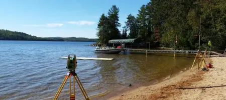
Our boundary retracement surveys precisely establish property lines using historical records and modern GNSS technology. We serve cottage owners, municipalities, and developers requiring legal boundary clarification for land transactions or development projects. Our work meets provincial cadastral standards and includes detailed documentation for official registration.
Drone Photogrammetry
We utilize unmanned aerial vehicles (UAVs) for topographic mapping, stockpile volume calculations, and construction monitoring. This technology provides cost-effective, high-resolution data for subdivision plans, environmental assessments, and infrastructure projects. Our processing includes georeferenced orthomosaics and 3D models compliant with surveying standards.
Severance Surveys
We facilitate property severances through Planning Act Consent Applications, handling legal requirements and municipal coordination. Our services include boundary analysis, plan preparation, and client guidance through approval processes. This supports landowners seeking to divide properties for sale, development, or family transfers while maintaining regulatory compliance.
Engineering Surveys
Our engineering surveys support infrastructure projects with precise control networks, horizontal/vertical benchmarks, and as-built documentation. Applications include road construction, utility installations, and building foundations. We employ robotic total stations and GNSS systems to ensure alignment with design specifications and tolerance requirements.
Crown Lands Surveys
We conduct surveys for Crown Reserves, two-storey boathouses, and public land transactions. This includes historical research, field verification, and legal documentation for government agencies and private claimants. Our team maintains expertise in provincial Crown land regulations and First Nations land management requirements.
People
Paul Miller
Managing Partner
Commissioned OLS (1980) and CLS (1994), Paul has 40+ years of experience in cadastral surveys, expert court testimony, and business management. He contributes to AOLS committees and oversees complex boundary disputes and corporate client projects.
Kevin Smith
Managing Partner
CLS (2007) and OLS (2012) with expertise in geomatics engineering. Kevin specializes in photogrammetry, GNSS networks, and municipal infrastructure projects. He leads technology integration and serves on AOLS academic committees.
Taylor DeRuiter
Ontario Land Surveyor
OLS (2024) with experience in legal boundary calculations and cadastral projects. Taylor focuses on title research, field operations, and engineering surveys while pursuing Professional Engineering certification.
Al Karklins
Canada Lands Surveyor
CLS with 50+ years of international experience in boundary, engineering, and topographic surveys. Al provides technical oversight for complex projects and contributes expertise from his roles in academia and utility sector management.
Questions
What survey services do you offer?
We provide boundary surveys, drone mapping, severance planning, Crown land surveys, engineering layout, and historical title research for residential, commercial, and government clients.
How long has your firm been operating?
P.A. Miller Surveying has delivered surveying services since 1980, with our principals maintaining professional licenses for 20-40 years.
What technology do you use?
We employ Leica GNSS systems, high-precision total stations, UAV photogrammetry, and Microsurvey software to ensure accurate, efficient project completion.
Which areas do you serve?
Our survey teams operate across Eastern Ontario, covering Hastings, Frontenac, Prince Edward County, and extending to Haliburton and Northumberland regions.
How long do estimate requests take?
Free estimates require 7-10 business days. Field work scheduling occurs 4-6 weeks after deposit receipt, with timelines adjusted for existing clients.