
Business Details
37 Years
experience
Professional Land Surveying Services in Northern BC
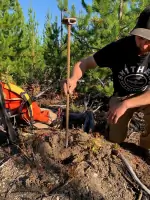
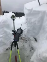
HBH Land Surveying has been a leader in professional survey services for over 30 years, delivering precise and reliable results to clients across northern British Columbia. Our team of certified professionals combines decades of experience with advanced technology, including GPS, drones, and laser scanning, to ensure accurate and efficient project completion. With offices in Smithers and Prince George, we serve a diverse clientele from the Highway 16 corridor to the Yukon border, prioritizing local hiring and maintaining strong relationships with First Nations communities.Our commitment to safety, quality, and environmental stewardship is reflected in our BCCSA Certificate of Recognition and comprehensive in-house programs. We specialize in legal surveys, land development, engineering surveys, and specialized services like LIDAR drone mapping, supporting industries ranging from mining to construction.

Services
Legal Surveys
Land Development
Engineering Surveys
Construction Surveys
Mining Surveys
LIDAR Drone Services
Bathymetric Surveys
Aerial Topographic Surveys
High Accuracy Control Networks
Tunneling Surveys
Details
- Year established: 1989
Highlights and features
- We have over 30 years of experience in land surveying in northern BC.
- Our client-focused approach ensures accurate and efficient project completion.
- We utilize advanced technology including drones and laser scanning.
- We prioritize hiring local and maintaining relationships with First Nations communities.
- Our team holds affiliations with leading professional organizations.
Associations and certifications
- BCCSA Certificate of Recognition
Services
Legal Surveys
Our legal surveys address subdivision, easements, and property boundary needs, performed by registered British Columbia Land Surveyors. We ensure compliance with local regulations and provide precise documentation for mortgages, permits, and land transactions. Decades of expertise guarantee accurate results for both simple and complex projects.
LIDAR Drone Services
We offer high-accuracy LIDAR drone surveys, capturing up to 1000 acres daily with 3cm precision. This technology enables safe data collection in challenging areas, producing orthophotos and point clouds for engineering and environmental projects. Seamless integration ensures deliverables are ready for immediate use.
Engineering Surveys
Our engineering surveys provide control networks, layout, and tunneling solutions for infrastructure projects. With in-house Geomatics Engineers, we deliver precision for complex developments, ensuring alignment with design specifications and regulatory standards. Services support industries ranging from transportation to energy.
Land Development
We guide clients through land development processes, coordinating with municipalities and agencies to secure permits and approvals. Our team navigates regulatory frameworks for subdivisions, strata lots, and lease agreements, ensuring compliance with environmental and zoning requirements.
Mining Surveys
Our mining surveys support claim-to-lease transitions, volume calculations, and site layout for mineral operations. We combine field expertise with advanced tools to manage earthworks, road design, and precision control, ensuring efficient resource extraction and regulatory compliance.
Questions
What areas do you service?
We service northern British Columbia, including the Highway 16 corridor from Prince George to Prince Rupert, Highway 37 from Kitimat to the Yukon border, and remote locations.
What types of surveys do you offer?
We provide legal surveys, engineering surveys, construction surveys, mining surveys, and specialized services like LIDAR drone mapping and bathymetric surveys.
Do you work with First Nations communities?
Yes, we maintain respectful relationships with First Nations communities, consulting on land tenure and hiring local professionals for fieldwork and support roles.
How long have you been in business?
HBH Land Surveying has provided professional services since 1989, with over 30 years of experience in northern British Columbia.
What technologies do you use?
We utilize GPS, total stations, drones, laser scanners, sonar, and LIDAR technology to ensure high-accuracy data collection and efficient project execution.
Reviews (1)
Ken Yorston
Jun 15, 2021
Report
They went out of their way to help me with a small task. I have used HBH on numerous projects and have always been satisfied with their work.